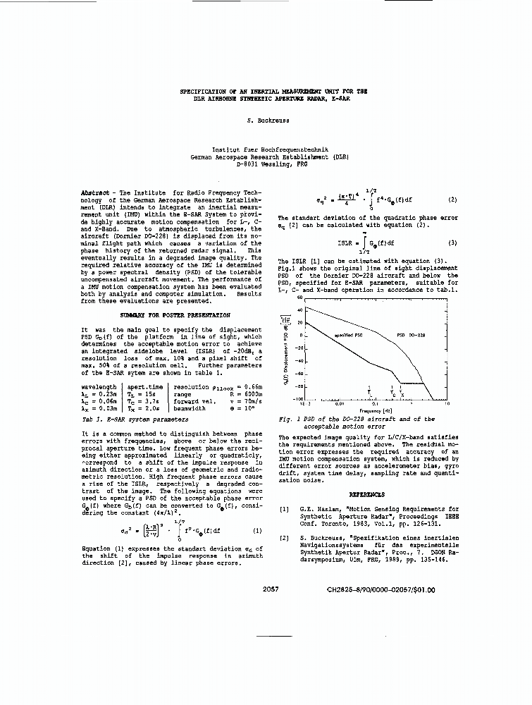
Loading [MathJax]/extensions/MathMenu.js
Stefan Buckreuss - IEEE Xplore Author Profile

Showing 1-23 of 23 results

Filter Results

Show

Results

The paper provides an overview of the German TanDEM-X satellite mission status and its ongoing science activities. The global digital elevation model (DEM) of TanDEM-X became available in 2016 and surpassed all expectations: It has 99.9% coverage, 12-m posting, absolute height accuracy of approximately 1 m and a relative height error (standard deviation) of 0.8 m. This unique data set has been ava...Show More
The paper provides an up-to-date overview of the German TanDEM-X satellite mission status and its ongoing science activities. The global digital elevation model (DEM) of TanDEM-X became available in 2016 and surpassed all expectations: It has 99.9% coverage, 12-m posting, absolute height accuracy of approximately 1 m and a relative height error (standard deviation) of 0.8 m. This unique data set h...Show More
This article reports the Phase A study results of the interferometric extension of the high-resolution wide-swath (HRWS) mission with three MirrorSAR satellites. According to the MirrorSAR concept, small, low-cost, transponder-like receive-only satellites without radar signal demodulation, digitization, memory storage, downlink, and synchronization are added to the planned German X-band HRWS missi...Show More
The paper provides an up to date overview of the German TanDEM-X satellite mission status and its ongoing science activities. In June 2020 TanDEM-X reached his 10 years of successful operation - a view forward will be presented in the final paper. The global digital elevation model (DEM) of TanDEM-X became available in 2016 and surpassed all expectations: It has 99.9% coverage, 12-m posting, absol...Show More
TanDEM-X is a formation flying interferometer consisting of two SAR satellites. Together they acquire bistatic SAR data of the earth in order to generate a global digital elevation model as well as individual scientific interferometric datasets on user request. This article gives an overview about ten years of acquisition and formation planning for the TanDEM-X mission. This planning on the one ha...Show More
The paper provides an up to date overview of the German TanDEM-X satellite mission status and its ongoing science activities. In June 2020 TanDEM-X will reach his 10 years of successful operation - a view back and forward will be presented in the final paper. The global digital elevation model (DEM) of TanDEM-X became available in 2016 and surpassed all expectations: It has 99.9% coverage, 12-m po...Show More
The paper provides an up to date overview of the German TanDEM-X satellite mission status and its ongoing science activities. The global digital elevation model (DEM) of TanDEM-X became available in 2016 and surpassed all expectations: It has 99.9% coverage, 12-m posting, absolute height accuracy of approximately 1 m and a relative height error (standard deviation) of 0.8 m. This unique data set h...Show More
TerraSAR-X and its almost identical twin satellite TanDEM-X have provided high resolution radar images and Digital Elevation Models with unprecedented accuracy for years. Between December 2010 and early 2015, radar data of all land surfaces has been acquired and as of September 2016 the final global DEM dataset has been available. Furthermore a science phase generating radar products for scientifi...Show More
TSX, an advanced synthetic aperture radar satellite, launched on June 15th 2007 and the almost identically rebuild TDX satellite, launched on June 21th 2010 serve two challenging radar missions. First: The TerraSAR-X mission, providing high quality SAR data for scientific and commercial purposes, covering a large variation of SAR modes from a high resolution staring spotlight mode with 1 m resolut...Show More
TerraSAR-X is a new German radar satellite that was launched in June 15, 2007. It carries a high frequency X-band SAR sensor that can be operated in three different modes and various polarizations. The Spotlight-, Stripmap- and ScanSAR-modes provide high resolution images for detailed analysis as well as wide swath data whenever a larger coverage is required. These high geometric and radiometric r...Show More
This paper describes the TerraSAR-X mission concept within the context of a public-private partnership (PPP) agreement between the German Aerospace Center (DLR) and the industry. It briefly describes the PPP concept as well as the overall project organization. This paper then gives an overview of the satellite design and the corresponding ground segment, as well as the main mission parameters. Aft...Show More
TerraSAR-X, the first national German remote-sensing satellite, was launched on June 15, 2007. It carries an X-band high-resolution synthetic aperture radar (SAR) instrument featuring imaging modes like StripMap, ScanSAR, and, particularly, SpotLight in a variety of different polarization modes. Primary mission goal is the provision of both science and commercial users with a variety of products f...Show More
TerraSAR-X is Germany's first national remote sensing satellite being implemented in a public-private partnership between the German Aerospace Centre (DLR) and EATS Astrium GmbH. TerraSAR-X was launched on June 15, 2007 and will supply high-quality radar data for purposes of scientific observation of the Earth for a period of at least five years. At the same time, it is designed to satisfy the ste...Show More
TerraSAR-X is Germany's first national remote sensing satellite being implemented in a public-private partner-ship between the German Aerospace Centre (DLR) and EADS Astrium GmbH. TerraSAR-X was launched on June 15th, 2007 and will supply high-quality radar data for purposes of scientific observation of the Earth for a period of at least five years. At the same time it is designed to satisfy the s...Show More
TerraSAR-X is Germanypsilas first national remote sensing satellite being implemented in a public-private partnership between the German Aerospace Centre (DLR) and EADS Astrium GmbH. TerraSAR-X was launched on June 15th, 2007 and will supply high-quality radar data for purposes of scientific observation of the Earth for a period of at least five years. At the same time it is designed to satisfy th...Show More
TerraSAR-X is Germany’s first national remote sensing satellite being implemented in a public-private partnership between the German Aerospace Centre (DLR) and EADS Astrium GmbH, with a significant financial contribution from the industrial partner. This radar satellite, which is to be launched in June 2007 will supply high-quality radar data for purposes of scientific observation of the Earth for...Show More
The objective of TerraSAR-X is the setup of an operational space borne X-Band SAR system in order to produce remote sensing products for commercial and scientific use. The TerraSAR-X project is conducted under the aegis of the DLR Space Flight Management and comprises a space and a ground segment. The space segment is designed and built by ASTRIUM GmbH, the ground segment is set up by several inst...Show More
"ProSmart" is the name of a remote sensing project established in the first phase of a future commercial SAR and hyperspectral scanner satellite mission. Research work in the past has shown the commercial potential of combined SAR and hyperspectral scanner data. It is the purpose of ProSmart now to identify the market needs and to develop a set of highly profitable products. The airborne experimen...Show More
This paper presents first the relevant parameters of the experimental E-SAR system for single- and repeat-pass SAR interferometry. The implementation of the different interferometric operation modes is described and special attention is paid to the problems posed by the unstable airborne platform. Each interferometric mode is described including the solution of its critical problems. The given exa...Show More
Since the beginning of 1994 the Institut fu/spl uml/r Hochfrequenztechnik of the German Aerospace Center (DLR) has been operating an experimental airborne SAR E-SAR with a P-band radar front-end. The microstrip patch array antenna allows a signal bandwidth of slightly more than 10% of the 450 MHz carrier frequency. The radar is polarimetric on a pulse-to-pulse basis.Show More
Two new motion compensation methods for airborne SAR are presented. Both methods are based on the evaluation of acceleration data measured by an Attitude and Heading Reference System (AHRS). The motion compensation algorithms were developed for the Experimental SAR System (E-SAR) of DLR which operates in L/C/X-Band. It is installed in a small Dornier Do-228 turboprop aircraft. Due to atmospheric t...Show More